Discrete Global Grid Systems (DGGS) research
A Discrete Global Grid System (DGGS) is a unique type of spatial reference system comprising of a hierarchy of uniquely identifiable discrete grid cells that span the globe at multiple resolutions. Several schemes for tesselation and indexing schemes exist and DGGS can support efficient management, storage, integration, exploration, mining, and visualisation of large geospatial datasets. We conduct research into innovative DGGS indexing and storage software and query APIs to integrate, visualise and analyse arbitrary raster and vector data and perform ML workloads on DGGS-based datacubes.
Our DGGS-related Publications
Kmoch, A., Sahr, K., Chan, W. T., and Uuemaa, E.: IGEO7: A new hierarchically indexed hexagonal equal-area discrete global grid system, AGILE GIScience Ser., 6, 32, DOI: 10.5194/agile-giss-6-32-2025, 2025.
Kmoch, A., Bovy, B., Magin, J., Abernathey, R., Coca-Castro, A., Strobl, P., Fouilloux, A., Loos, D., Uuemaa, E., Chan, W. T., Delouis, J.-M., and Odaka, T.: XDGGS: A community-developed Xarray package to support planetary DGGS data cube computations, Int. Arch. Photogramm. Remote Sens. Spatial Inf. Sci., XLVIII-4/W12-2024, 75–80, DOI: 10.5194/isprs-archives-XLVIII-4-W12-2024-75-2024, 2024.
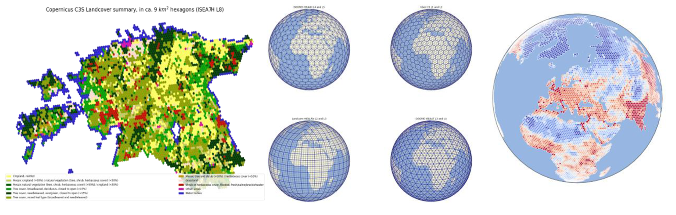
Kmoch, A., Vasilyev, I., Virro, H., & Uuemaa, E. (2022). Area and shape distortions in open-source discrete global grid systems. Big Earth Data, 6(3), 256–275. DOI: 10.1080/20964471.2022.2094926
Kmoch, A., Matsibora, O., Vasilyev, I., and Uuemaa, E.: Applied open-source Discrete Global Grid Systems, AGILE GIScience Ser., 3, 41, DOI: 10.5194/agile-giss-3-41-2022, 2022.
More detailed background articles
pydggsapi - an open-source OGC API DGGS web service
pydggsapi (GitHub repository) is an open-source web API to discover DGGS datasets through the OGC DGGS API standard. The…
IGEO7 - an Equal-Area Hexagonal DGGS
Uber H3 has revolutionized spatial indexing, but its cell sizes vary a lot, i.e. its cells aren’t equal-area, skewing…
XDGGS - Planetary Data cubes
How XDGGS is Bringing Planetary Data to Life Have you ever looked at a flat world map and wondered why Greenland looks…
DGGS Info - Learn more about DGGS
For developers and data scientists, the shift from traditional map projections to Discrete Global Grid Systems (DGGS) is…
AGILE 2021 DGGS Workshop
We hosted a DGGS workshop as part of the AGILE Conference 2021 (Association of Geographic Information Laboratories in…


