An eco-hydrological modelling parameters dataset derived from the Soil Map of Estonia.
We have developed the EstSoil-EH dataset as a machine-readable and enriched version on the base of the Soil Map of Estonia.
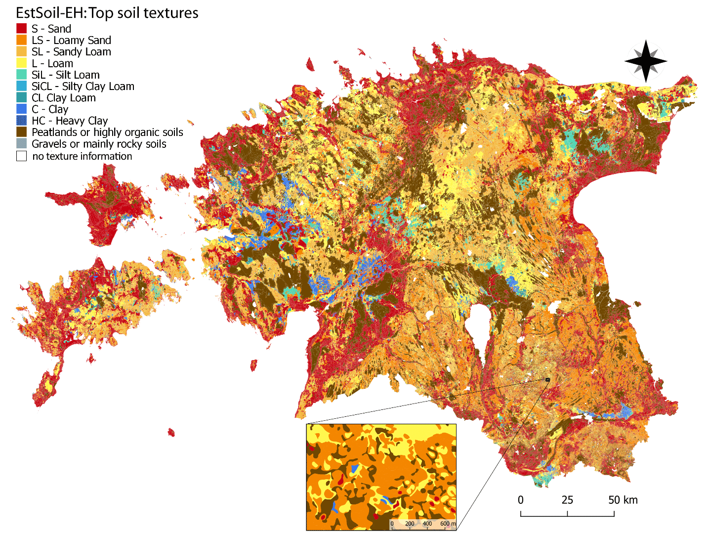
The national soil map is a vector dataset that maps more than 750.000 soil units throughout Estonia at a scale of 1:10.000. It is the most detailed and information-rich dataset for soils in Estonia. For each soil unit, it describes the soil type, quality, texture, and layer information with a series of complex text codes. However, to use it as an input for numerical modelling using process-based physical models, these text codes must be translated into extract and derive numerical values and exact classes, for example such as:
- soil profiles (e.g., layers, depths)
- texture classes and percent of fine earth fraction (clay, silt, sand components)
- coarse fragments and rock content
- physical variables related to water and carbon (bulk density, hydraulic conductivity, organic carbon content)
Detailed data description article:
EstSoil-EH, latest version v1.2c ( download from Zenodo ), containing derived numerical values for the following data in all of the mapped soil units. A scientific data paper has been published in the ESSD journal:
Alexander Kmoch, Arno Kanal†, Alar Astover, Ain Kull, Holger Virro, Aveliina Helm, Meelis Pärtel, Ivika Ostonen and Evelyn Uuemaa, 2021, EstSoil-EH: a high-resolution eco-hydrological modelling parameters dataset for Estonia, Earth Syst. Sci. Data, 13, 83–97, https://doi.org/10.5194/essd-13-83-2021
Contact/feedback form and mailing List:
If you have any requests, feedback for us or want to get in touch regarding the EstSoil-EH dataset and its development and improvement, you can use our contact form
If you would like to be updated on new versions, which might include bugfixes and newer algorithms, or suggest improvements, report issues, offer collaboration etc, please subscribe to our email list
Download:
The latest version of the dataset is EstSoil-EH v1.2c and is available as Shapefile and GeoPackage on Zenodo: https://doi.org/10.5281/zenodo.3473289 including additional supplemental materials and metadata.
License:
The dataset is distributed under the Open Database License (ODbL) v1.0, which is similar to the Creative Commons Licenses you may know. You are free to copy, distribute and use the database, produce works from the database and to modify, transform and build upon the database to your needs. As long as you attribute/cite us here, and if you wish to redistrbute your derived dataset then you need to keep it open. In particular, if you use this dataset or parts, you must include a notice associated as such below, and you must redistribute derived work under the same or compatible license.
Contains information from EstSoil-EH v1.2c, which is made available
here under the Open Database License ODbL
If you use parts or the whole the dataset in your work (consulting, research, planning, reports, etc.) please cite the article and the data deposit.
Explore EstSoil-EH interactively:
Visit our demo website: https://estsoil-eh.web.app/
Available data fields:
| name of variable per mapped soil unit | data_type | description |
|---|---|---|
| idx | int64 | unique row index for joining |
| orig_fid | int64 | row index for Landboard original Soil Map of Estonia |
| est_soiltype | string | Estonian soil type |
| wrb_code | string | FAO WRB soil type (1st and 2nd level) |
| wrb_main | string | FAO WRB main soil type (1st level) |
| Loimis1 | string | Estonian texture description |
| est_txcode | string | reconstructed error-free interpretation of Estonian texture description |
| nlayers | number | number of recognized layers/horizons |
| ZMX | float64 | depth in mm: max depth of the sample analysed soil profile in the mapped soil unit |
| Z1-4 | float64 | depth in mm: the bottom of the layer |
| EST_TXT1-4 | string | Estonian texture class |
| LXTYPE1-4 | string | USDA texture class |
| EST_CRS1-4 | string | Estonian coarse fragment type |
| SAND1-4 | int64 | % mass of fine earth fraction |
| SILT1-4 | int64 | % mass of fine earth fraction |
| CLAY1-4 | int64 | % mass of fine earth fraction |
| ROCK1-4 | int64 | % volumetric |
| SOC1-4 | float64 | % soil weight |
| BD1-4 | float64 | g/cm³ |
| K1-4 | float64 | mm/hr |
| AWC1-4 | float64 | mm H₂O/mm soil |
| unit_area | float64 | area in m² |
| slp_mean | float64 | mean slope, calculated from DEM |
| slp_median | float64 | median of slope |
| slp_stdev | float64 | standard deviation |
| twi_mean | float64 | mean terrain wetness index, calculated from DEM |
| twi_median | float64 | median of terrain wetness index |
| twi_stdev | float64 | standard deviation |
| ls_mean | float64 | ls-factor, calculated from DEM |
| ls_median | float64 | median ls-factor |
| ls_stdev | float64 | standard deviation |
| tri_mean | float64 | terrain roughness index, calculated from DEM |
| tri_median | float64 | median of terrain roughness index |
| tri_stdev | float64 | standard deviation |
| area_drain | float64 | area per unit under a (e.g., tile-) drainage regimen |
| drain_pct | float64 | percent of the area of the soil unit under drainage |
| area_arable | float64 | area per unit of land use/land cover type arable land |
| arable_pct | float64 | percent of the area of the soil unit of land use/land cover type arable land |
| area_forest | float64 | area per unit of land use/land cover type forest |
| forest_pct | float64 | percent of the area of the soil unit of land use/land cover type forest |
| area_grassland | float64 | area per unit of land use/land cover type grassland |
| grassland_pct | float64 | percent of the area of the soil unit of land use/land cover type grassland |
| area_wetland | float64 | area per unit of land use/land cover type wetland |
| wetland_pct | float64 | percent of the area of the soil unit of land use/land cover type wetland |
| area_urban | float64 | area per unit of land use/land cover type urban |
| urban_pct | float64 | percent of the area of the soil unit of land use/land cover type urban |
| area_water | float64 | area per unit of land use/land cover type water |
| water_pct | float64 | percent of the area of the soil unit of land use/land cover type water |
| area_other | float64 | area per unit of land use/land cover type other |
| other_pct | float64 | percent of the area of the soil unit of land use/land cover type other |
During the review process several original attributes, such as “värv” had to be dropped as they didn’t fulfill a function and we couldn’t justify its use case to the reviewers (or any international audience). A version with this attribute joined back in is available on request. Please get in touch if you would like to use original soilmap attributes together with EstSoil-EH.
Older versions:
- EstSoil-EH, version v1.1 https://zenodo.org/record/3473290 from Zenodo
- EstSoil-EH, version v1.0 https://zenodo.org/record/3473290 from Zenodo


